
Picking the right weather window for a backcountry ski trip in Australia is a critical factor in having a safe and enjoyable trip. But with so many automated and human forecasts available these days, what’s the best way to determine what’s really likely to happen? This post provides some tips on which forecasting services to use, what elements to look for and how to be relatively confident about the real outcome. A big disclaimer – the author is not a trained Meteorologist, so feel free to add a comment if you have suggestions for improvements.
What makes it snow in Australia?
I always like to tell international friends that it’s a miracle we even get snow in Australia and that the skiing can be as fun as anywhere in the world on the right day. So how do we even get snow here in the first place?
Firstly, latitude, or how far Australia is down in the Southern Hemisphere is a massive factor in terms of exposure to cold weather. However, if the Australian Alps were at an equivalent latitude in the Northern Hemisphere, they’d be roughly in line with Algiers in Northern Africa or Los Angeles in the USA. Of course, the Atlas Mountains and Mammoth Mountain in those regions both get snow, but they are up to double the altitude of the 2,228m Mount Kosciuszko.
However, Southern Australia is very exposed to the weather emanating from the Roaring Forties, the band of weather systems that circle the globe above Antartica that is unimpeded by any large land mass. This results in low pressure systems sucking very cold air from deep under Australia across a huge area of ocean and impacting our highest peaks. The image below shows one of these systems to the bottom left, with the dappled cloud indicating cold air being sucked North.
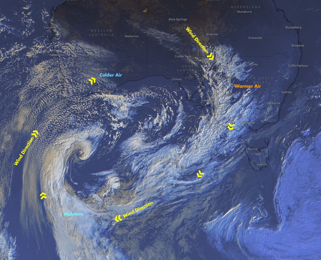
As low pressure systems spin clockwise, they typically suck warmer air from Northern Australia over the mountains first, often bringing northerly winds, warmer temperatures and rain before the main front crosses the alps with cooler temperatures, South Westerly winds and snow. Once these cold fronts pass, the temperatures normally rise quickly, leading to poor snow quality within a day or two after a big powder dump. If you want to ski cold, dry powder in Australia, you really need to be there at the height of the storm or in the hours immediately afterwards.
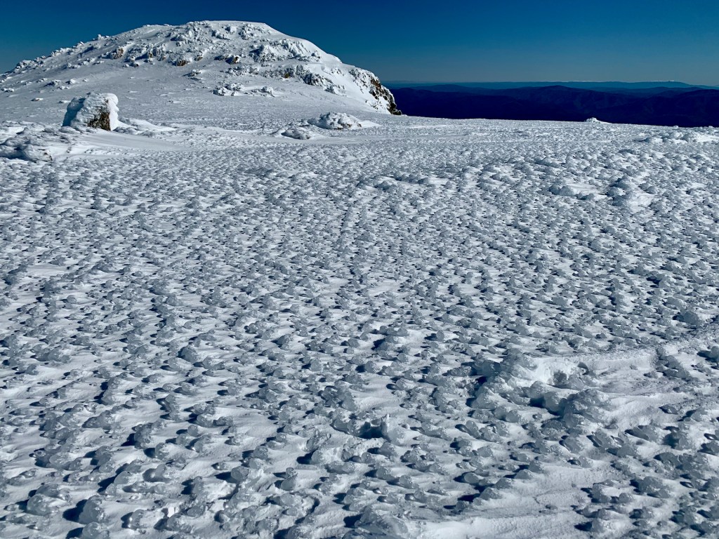
Most people will stay within the ski resorts during these storms to milk a powder day whilst avoiding the risks of dangerous weather, low visibility and avalanche risks in the backcountry until the weather’s calmed down the snow’s consolidated. Australia can have some of the worst alpine weather on the planet, driven by winds in excess of 100kmh and moist snow, resulting in wind chill temperatures of well below -20ºC.
The other major factor is the mountains’ altitude and the height at which moisture will turn to snow, otherwise known as the Freezing Level. Australia’s mountains are old and relatively low, with all ski resorts under 2000m altitude. In the case of Thredbo, the base is 1300m, mid mountain 1700m and top of the main lift 1930m. At Perisher, the base lift is around 1700m and peaks just under 2000m. Unfortunately, many storms’ freezing level are often around 1700-1800m, exacerbated by climate change, resulting in rain on the lower resort slopes and wet snow on the higher slopes. To be sure of good snow deep into the valleys, you really want the freezing level to be around 1200m
All is not lost, as the main backcountry ski areas are largely above 1700m, topping out at 2200m. This means that while the resorts are often suffering moist conditions lower down, the snow base is often steadily building in the backcountry.
The final big factor to consider is slope aspect. While southerly slopes are best protected from sun melt, Australia’s strong prevailing South Westerly winds mean that loose snow is usually blown off these slopes onto ones facing north easterly. For this reason, all Australian ski resorts are on predominately east and north facing slopes. In fact, the main range peaks and plateau often resembles a huge ice cap with completely un-skiable snow in mid winter, leading many people to wait for spring, warmer temps and corn snow to go backcountry skiing.
Divining the weather forecasts
Now that we know what makes it snow, how do we know which weather forecast will be the most accurate for the Australian Alps? This is where we venture into territory that many people may have opposing views on, so I can only outline what I tend to find effective myself.
Two weeks out…
The first step is to look for likely long range forecasts of a cold front hitting the Australian Alps. Human forecasters like Pete ‘The Frog’ Taylor are very good at spotting these systems when they’re still in the Atlantic Ocean, or more than two weeks away. Automated models like Snow-forecast.com provide an affordable paid subscription for 12 day forecasts. They use GFS weather model data, overlaid with specific detail about mountain heights for a generally accurate automated forecast.
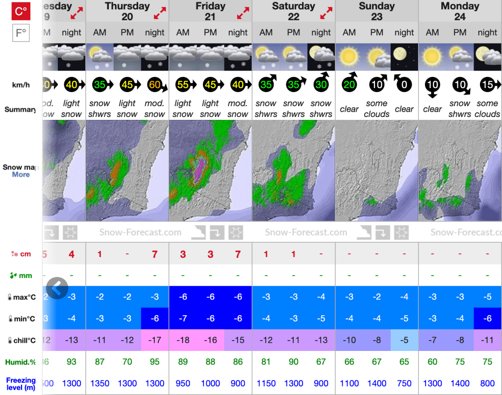
All we’re looking for at this stage is a blip in the long range forecast to indicate that there’s a cold front coming with likely snow. Cold temps and a lower freezing levels are critical here as opposed to getting excited by the actual snow volume. From this you can know to start keeping an eye on a range of dates where there’ll be an initial front hit with strong winds, hopefully some moisture and cold temps behind that, clearing to sunny days afterwards. Yes, there’s probably a storm coming, but any certainty on snow volumes is pure speculation.
A big caveat with the long range forecasts is whether the storm front will be pushed too far south and below Australia once it gets closer. This happened consistently throughout the 2020 season with almost all fronts being pushed down by persistent high pressure systems. We also had a series of East Coast Lows in 2020 that sucked tropical moisture from the Equator into the Tasman Sea and then back onto the Australian Alps, similar to the ‘Pineapple Express’ that hits West Coast USA and Canada. While the first of these systems intersected with a cold front and dumped an unexpected metre of snow, the others poured rain to the highest peaks for days on end.
7 days out…
By this stage, the models should be aligning around which days will be snowy and a bit more certainty around snow volumes. This is when automated forecast sites like Windy.com become very handy to dive into granular detail around wind direction, temperatures, cloud cover and snow accumulation.
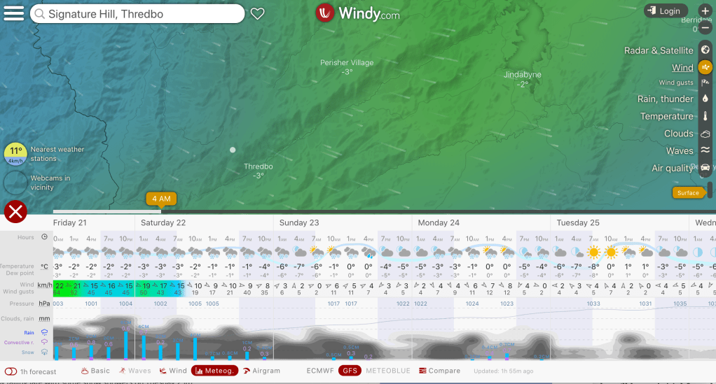
Windy.com provides data sources from both the ECMWF and GFS models (and others) for different calculations of the forecast to switch between.
With a week to go, other human forecasters like Mountainwatch’s The Grasshopper and SnowsBest alongside The Frog will provide their own interpretations of the data. The closer agreement they all have, the more certain the forecast generally is. But if one is predicting rain and another predicts a metre of snow from the same storm, one of them will be very, very wrong. I always err on the side of pessimistic forecasts in this case and hope to be pleasantly surprised if they’re wrong.
Bear in mind that human snow forecasters are usually skiers themselves, so will get just as excited about a potential powder day as the rest of us, which I personally think skews their forecasts to being too optimistic at times.
From a week out, I also start looking at trending patterns in the automated models. For example, if I’m relying on a clear, calm day for a backcountry trip, I keep an eye on things like wind speed and cloud cover trends for the target days in the week prior. If the models are all trending to winds dropping and skies clearing you can have more confidence this will be the case on the day.
3 days out…
This is when we can have a high degree of confidence in the forecasts and be making final calls on big decisions like “Should we camp out Saturday night, or will the winds be too strong?”. When the forecasts are still wavering around about what might actually happen, such as rain to high elevations, it’s important to have a buffer in your plans so you can pull out at the last minute if the weather’s too risky.
In this final period, I’ll also look at more general forecasts like the Bureau of Meteorology’s multi day forecast for an alpine location. This gives an overview of what the weather will be like, but I don’t rely on it for anything too specific. It’s also worth checking the BOM Weather Warnings at this stage, especially for high winds and the classic ‘Sheep Graziers Alert’. The BOM Forecast Rainfall and 4 Day (Synoptic) Forecast are other good indicators of likely precipitation over a broad area or when specific weather fronts will hit.
On the day…
It’s always important to do a last minute check of the weather forecast for that day and any subsequent days you might be on an extended backcountry trip. Most high peaks in the main range have mobile phone reception to keep checking forecasts while you’re in the field on longer trips.
I make frequent use of the Thredbo Top Station Observations for hourly updates on wind speed and temperature, largely to spot any trends such as increasing wind speed. Note that if the wind speed meter on this station shows ‘Calm’ after high winds an hour beforehand, the wind speed sensor has probably frozen solid – never a good sign!
While I don’t pay much attention to the ski resorts’ own weather forecasts, which are just repurposed from other sources, their daily snow report can be handy for verification of recorded snowfall overnight. Looking on the resort web cams is also useful to check live conditions and general snow coverage, especially at lower elevations.
The final word…
Weather forecasting is remarkably accurate these days, so you can be generally confident of what’s coming once you’re a few days out from your intended trip dates. However, even the best forecasts can be wildly wrong with localised conditions, mainly with regards to wind speeds, so always be prepared to ride out some unexpected rough weather.
The important thing is being aware of what factors drive the weather in the first place, having a range of human and automated sources you’re drawing forecasts from, and being able to decipher the average of those. In doing this, you’ll have a reasonably accurate picture of what’s going to happen and have prepared your trip plan and equipment accordingly.
